

Dress Rehearsal
Revved up the engine one more time. 12 miles from St. Vincent's to T's baseball game at Taney Park. Point to point is a bit shorter than that, so I had to add some mileage through Fairmount Park that included the Falls Ave/Conshohocken St. hill and plopped me onto MLK by Strawberry Mansion Bridge, whereupon I ran 6 marathon pace miles to finish up the course.
Doing six miles at 6:00 pace was not a problem, even with all the people on the path whom I had to weave around (good practice for the opening mile). I was working too hard today, however, to see realistically doing 26 of those. Boston presents a conundrum, as for once I want to start conservative but Boston is not a course that lends itself to doing that. The first miles are steady downhill and the main hills only come after about 16 miles. Run too fast at the outset (as many people do) and you're toast by the time you hit Newton, but if I run too conservative in the outset I'm afraid of squandering these faster miles.
So I'm thinking I'll start out at 6:10 or so and assess how I'm feeling. If I feel like I'm working then I'll even drop it down a bit to 6:15 range until I get to mile 16. This is where the work starts, the infamous hills of Newton. If I can do them strong then its a gradual downhill to the finish and I'll do fine. If the hills waste me then I'll be moaning and complaining here next week.
As I write this it sounds like a smart strategy. I also want to drive the Newton part again when we get to Boston. I want to know that piece of the course. But I feel ready. Of course anything can happen on marathon day, but as of right now I'm ready for sub 2:40 on a good day (6:07 pace) or sub 2:45 (still a pr) no matter what, provided I run smart.
Today reaffirmed that. 12 miles in 85:38.
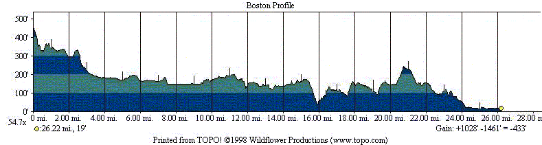
And for something completely different and for Boston geeks only. I was looking at Hal Higdon's coffeetable book on Boston, which has some good advice by Bill Squires (see here for an online version) as well as an elevation map. This elevation map is much more jagged and steep than the one on the official marathon website, and this instantly intrigued me.
For the "official" elevation map go here (scroll to the bottom of the pdf) and compare it to the course map I'm pasting on the bottom of this post. I really had to dig to find this map on the web, and unfortunately I didn't remember the site I got it from but it is consistent, and more detailed, than the one in the Higdon book. I find it much more credible than the official map. The official map seems to smooth out the ups and downs to create a much kinder, gentler set of hills which seems misleading, especially as being prepared for the downhills is as important as being set for the uphills.
Why do the race organizers do this? It seems pointless to soft-pedal hills that are so fabled.
Doing six miles at 6:00 pace was not a problem, even with all the people on the path whom I had to weave around (good practice for the opening mile). I was working too hard today, however, to see realistically doing 26 of those. Boston presents a conundrum, as for once I want to start conservative but Boston is not a course that lends itself to doing that. The first miles are steady downhill and the main hills only come after about 16 miles. Run too fast at the outset (as many people do) and you're toast by the time you hit Newton, but if I run too conservative in the outset I'm afraid of squandering these faster miles.
So I'm thinking I'll start out at 6:10 or so and assess how I'm feeling. If I feel like I'm working then I'll even drop it down a bit to 6:15 range until I get to mile 16. This is where the work starts, the infamous hills of Newton. If I can do them strong then its a gradual downhill to the finish and I'll do fine. If the hills waste me then I'll be moaning and complaining here next week.
As I write this it sounds like a smart strategy. I also want to drive the Newton part again when we get to Boston. I want to know that piece of the course. But I feel ready. Of course anything can happen on marathon day, but as of right now I'm ready for sub 2:40 on a good day (6:07 pace) or sub 2:45 (still a pr) no matter what, provided I run smart.
Today reaffirmed that. 12 miles in 85:38.
And for something completely different and for Boston geeks only. I was looking at Hal Higdon's coffeetable book on Boston, which has some good advice by Bill Squires (see here for an online version) as well as an elevation map. This elevation map is much more jagged and steep than the one on the official marathon website, and this instantly intrigued me.
For the "official" elevation map go here (scroll to the bottom of the pdf) and compare it to the course map I'm pasting on the bottom of this post. I really had to dig to find this map on the web, and unfortunately I didn't remember the site I got it from but it is consistent, and more detailed, than the one in the Higdon book. I find it much more credible than the official map. The official map seems to smooth out the ups and downs to create a much kinder, gentler set of hills which seems misleading, especially as being prepared for the downhills is as important as being set for the uphills.
Why do the race organizers do this? It seems pointless to soft-pedal hills that are so fabled.
posted by seebo | 3:45 PM
![]()
![]()
0 Comments:
Post a Comment
<< Home